
Chicago, Illinois – Ice coverage across the Great Lakes reached a seasonally significant threshold Monday, potentially affecting travel, shipping, and lake-effect snow near major Midwest roadways.
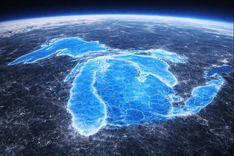
According to the NOAA Great Lakes Environmental Research Laboratory and the National Ice Center, total ice cover across all five lakes reached 50.6% as of Monday, based on satellite analysis dated Feb. 2. That level is above the long-term early-February average and continues a sharp upward trend observed over the past two weeks.

Lake-by-lake data show uneven but impactful conditions. Lake Erie reported 95.3% ice coverage, while Lake Huron reached 77.5%. Lake Michigan stood at 33.3%, Lake Superior at 34.3%, and Lake Ontario at 37.2%. Ice concentration is highest along shorelines and bays, particularly near population centers and transportation corridors.
The increase in ice coverage can influence regional weather patterns by limiting heat transfer from open water. Meteorologists note this often reduces lake-effect snowfall in heavily iced areas, while shifting snow bands farther downstream into less-frozen zones. For commuters along corridors such as Interstate 90 near Chicago and Cleveland, I-94 near Milwaukee, and I-75 in Michigan, rapidly changing visibility and localized snow bursts remain possible.
NOAA officials emphasize that ice conditions can fluctuate quickly with wind and temperature changes. While thicker ice may eventually stabilize some areas, ongoing cold air outbreaks could further expand coverage through mid-February.
The data are derived from the Great Lakes Surface Environmental Analysis, which combines satellite imagery collected within a 10-day window. The most recent update indicates just under 60% data confidence due to cloud cover, a common limitation during winter monitoring.
Students, young workers, and daily commuters are encouraged to monitor local forecasts closely, particularly when traveling near lake-adjacent highways during early morning and overnight hours.

